Log in
All resources
Create a design
281 Free Artworks of 1650 Maps
bibliothèque nationale de france
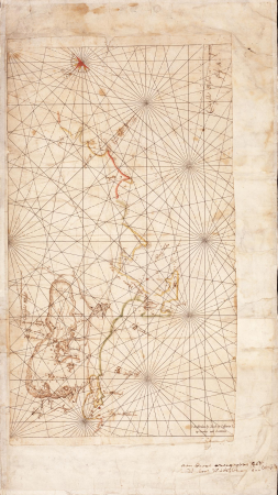
tresor des cartes geographiques (1659)
topographia helvetiae, rhaetiae et valesiae (1654) engravings
national library of poland
maps in the rijksmuseum amsterdam
baroque
philippe de la rué
nicolaes visscher
maps by nicolaes visscher i
maps by willem and johannes blaeu
tresor des cartes geographiques (1659)
17th-century maps of silesia
17th-century maps of xaintonge
maps by jodocus hondius ii
topographia braunschweig lüneburg (merian)
baroque
engravings by matthäus merian
baroque
tresor des cartes geographiques (1659)
1650s maps of the world
maps of paris from the david rumsey historical map collection
maps of paris by caspar merian
topographia bohemiae moraviae et silesiae (merian)
baroque
west seram regency
johannes nessel
map of modern syria by philippe de la rué
1650s maps of palestine
maps by gerard valck
atlas beudeker
bibliothèque nationale de france
maps of wales by humphrey llwyd
old maps of the stations of the exodus
1650s maps of palestine
17th-century maps of west africa
1650 maps of africa
johannes nessel
batavia castle
tresor des cartes geographiques (1659)
1650s maps of turkey
tresor des cartes geographiques (1659)
1650s maps of italy
tresor des cartes geographiques (1659)
1650s maps of china
tresor des cartes geographiques (1659)
1650s maps of ethiopia
tresor des cartes geographiques (1659)
1650s maps of denmark
tresor des cartes geographiques (1659)
1650s maps of hungary
tresor des cartes geographiques (1659)
1650s maps of the americas
tresor des cartes geographiques (1659)
1650s maps of asia
tresor des cartes geographiques (1659)
1650s maps of iran
tresor des cartes geographiques (1659)
1650s maps of france
tresor des cartes geographiques (1659)
1650s maps of greece
tresor des cartes geographiques (1659)
1650s maps of portugal
tresor des cartes geographiques (1659)
1650s maps of the americas
maps in the rijksmuseum amsterdam
17th-century maps of prussia
maps by daniel stoopendaal
biblical maps
greifswald in the 17th century
old maps of greifswald
alessandro baratta
old maps of genoa
tresor des cartes geographiques (1659)
1650s maps of the ottoman empire
tresor des cartes geographiques (1659)
1650s maps of the iberian peninsula
tresor des cartes geographiques (1659)
1650s maps of the holy roman empire
map of modern syria by philippe de la rué
1650s maps of palestine
maps in the rijksmuseum amsterdam
maps by willem and johannes blaeu
cartes generales de toutes les parties du monde (1658)
1650s maps of saxony
philippe de la rué
maps of troas
drawings by pieter jansz. saenredam in the beeldcollectie van de gemeente haarlem
nieuwe kerk, haarlem by pieter jansz. saenredam
atlas of the great elector
archipelagus orientalis
maps by willem and johannes blaeu
robert gordon of straloch
west seram regency
johannes nessel
maps in the rijksmuseum amsterdam
old maps of the ottoman empire
drawings by jacob toorenvliet in the rijksmuseum amsterdam
pen and ink drawings in the rijksmuseum amsterdam
maps of the byzantine levant
1650s maps showing history
map of ancient assyria by philippe de la rué
old maps of mesopotamia
maps in the rijksmuseum amsterdam
pampus (water)
eran laor cartographic collection
hendrik hondius the younger
eran laor cartographic collection
baroque
maps by nicolaes visscher i
maps by daniel stoopendaal
topographia bohemiae moraviae et silesiae (merian)
baroque
map of the bosphorus strait by guillaume sanson (1665)
bibliothèque nationale de france
maps of provence by pierre-jean de bompar
bibliothèque nationale de france
maps by willem and johannes blaeu
bibliothèque nationale de france
prints in the jordan schnitzer museum of art
maps by nicolaes visscher i
maps in the rijksmuseum amsterdam
gerard valck
maps of ports and fortresses of the mediterranean by marco boschini (1651)
bibliothèque nationale de france
maps of ancient israel by philippe de la rué
old maps of ancient israel
maps of chios by braun & hogenberg
bibliothèque nationale de france
maps of abyssinia by mercator-hondius
bibliothèque nationale de france
prints by wenzel hollar in the british museum
baroque
italia - di matteo greuter... - btv1b525056959
1650s maps of tuscany
maps of the dutch east india company - south africa
casparus lootsman
media from atlas of mutual heritage on dutch east india company
1650s maps of indonesia
prints of cartouches in the rijksmuseum amsterdam
maps in the rijksmuseum amsterdam
topographia helvetiae, rhaetiae et valesiae (1654) engravings
klingnau
maps in the british museum
prints by albert flamen
maps by willem and johannes blaeu
robert gordon of straloch
territorium argentoratense (1652 map)
bibliothèque nationale de france
maps of ports and fortresses of the mediterranean by marco boschini (1651)
bibliothèque nationale de france
1650s maps of bremen (state)
baroque
maps of ceylon by nicolaes visscher
maps in the rijksmuseum amsterdam
bibliothèque nationale de france
maps of limousin by jean fayen
topographia helvetiae, rhaetiae et valesiae (1654) engravings
history of appenzell
bremen in topographia saxoniae inferioris (merian)
baroque
maps of the byzantine levant
1650s maps showing history
eran laor cartographic collection
claes jansz. visscher (ii)
british library king's topographical collection
william henry toms
maps of bremen
maps of weser
map of modern syria by philippe de la rué
1650s maps of palestine
maps of the byzantine levant
1650s maps showing history
eran laor cartographic collection
claes jansz. visscher (ii)
bremen in topographia saxoniae inferioris (merian)
baroque
topographia helvetiae, rhaetiae et valesiae (1654) engravings
baroque
1650s maps of the americas
1658 maps
maps in the rijksmuseum amsterdam
gerard valck
1650s maps of the atlantic ocean
joan blaeu
1650s maps of switzerland
hans conrad gyger
topographia helvetiae, rhaetiae et valesiae (1654) engravings
schaffhausen in the 1650s
17th-century maps of the spanish empire
maps of the spanish netherlands
maps by willem and johannes blaeu
wachtendonk in the 1650s
maps in the rijksmuseum amsterdam
maps by frederick de wit
topographia helvetiae, rhaetiae et valesiae (1654) engravings
historical images of saint-maurice, switzerland
topographia helvetiae, rhaetiae et valesiae (1654) engravings
historical images of mulhouse
topographia helvetiae, rhaetiae et valesiae (1654) engravings
historical images of leuk
topographia helvetiae, rhaetiae et valesiae (1654) engravings
historical images of glarus (town)
topographia helvetiae, rhaetiae et valesiae (1654) engravings
rheinquelle
topographia helvetiae, rhaetiae et valesiae (1654) engravings
maps of biel/bienne
topographia helvetiae, rhaetiae et valesiae (1654) engravings
maps of chur
topographia helvetiae, rhaetiae et valesiae (1654) engravings
maps of fortifications in geneva
101 - 200 of 281
Next page
/ 3

![Treasure of geographical maps of the main states of the universe [...], 1659](https://cdn.creazilla.com/illustrations/10000859170/treasure-of-geographical-maps-of-the-main-states-of-the-universe-1659-md.jpg)


![Treasure of geographical maps of the main states of the universe [...], 1659](https://cdn.creazilla.com/illustrations/10001492378/treasure-of-geographical-maps-of-the-main-states-of-the-universe-1659-md.jpg)


![Treasure of geographical maps of the main states of the universe [...], 1659](https://cdn.creazilla.com/illustrations/10001323164/treasure-of-geographical-maps-of-the-main-states-of-the-universe-1659-md.jpg)
![Treasure of geographical maps of the main states of the universe [...], 1659](https://cdn.creazilla.com/illustrations/10000521357/treasure-of-geographical-maps-of-the-main-states-of-the-universe-1659-md.jpg)
![Treasure of geographical maps of the main states of the universe [...], 1659](https://cdn.creazilla.com/illustrations/10000420918/treasure-of-geographical-maps-of-the-main-states-of-the-universe-1659-md.jpg)
![Treasure of geographical maps of the main states of the universe [...], 1659](https://cdn.creazilla.com/illustrations/10000449944/treasure-of-geographical-maps-of-the-main-states-of-the-universe-1659-md.jpg)
![Treasure of geographical maps of the main states of the universe [...], 1659](https://cdn.creazilla.com/illustrations/10000314824/treasure-of-geographical-maps-of-the-main-states-of-the-universe-1659-md.jpg)
![Treasure of geographical maps of the main states of the universe [...], 1659](https://cdn.creazilla.com/illustrations/10001410826/treasure-of-geographical-maps-of-the-main-states-of-the-universe-1659-md.jpg)
![Treasure of geographical maps of the main states of the universe [...], 1659](https://cdn.creazilla.com/illustrations/10001567991/treasure-of-geographical-maps-of-the-main-states-of-the-universe-1659-md.jpg)
![Treasure of geographical maps of the main states of the universe [...], 1659](https://cdn.creazilla.com/illustrations/10001176342/treasure-of-geographical-maps-of-the-main-states-of-the-universe-1659-md.jpg)
![Treasure of geographical maps of the main states of the universe [...], 1659](https://cdn.creazilla.com/illustrations/10000659025/treasure-of-geographical-maps-of-the-main-states-of-the-universe-1659-md.jpg)
![Treasure of geographical maps of the main states of the universe [...], 1659](https://cdn.creazilla.com/illustrations/10001054877/treasure-of-geographical-maps-of-the-main-states-of-the-universe-1659-md.jpg)
![Treasure of geographical maps of the main states of the universe [...], 1659](https://cdn.creazilla.com/illustrations/10001292785/treasure-of-geographical-maps-of-the-main-states-of-the-universe-1659-md.jpg)
![Treasure of geographical maps of the main states of the universe [...], 1659](https://cdn.creazilla.com/illustrations/10000360844/treasure-of-geographical-maps-of-the-main-states-of-the-universe-1659-md.jpg)
![Treasure of geographical maps of the main states of the universe [...], 1659](https://cdn.creazilla.com/illustrations/10000397491/treasure-of-geographical-maps-of-the-main-states-of-the-universe-1659-md.jpg)


![Treasure of geographical maps of the main states of the universe [...], 1659](https://cdn.creazilla.com/illustrations/10000550553/treasure-of-geographical-maps-of-the-main-states-of-the-universe-1659-md.jpg)
![Treasure of geographical maps of the main states of the universe [...], 1659](https://cdn.creazilla.com/illustrations/10000485227/treasure-of-geographical-maps-of-the-main-states-of-the-universe-1659-md.jpg)
![Treasure of geographical maps of the main states of the universe [...], 1659](https://cdn.creazilla.com/illustrations/10001567990/treasure-of-geographical-maps-of-the-main-states-of-the-universe-1659-md.jpg)


![Totius Lemovici et confinium provinciaru quantum ad dioecesin Lemovicensen [sic] spectant novissima et fidissima descriptio / aut. Jo. Fayano M.L., between 1600 and 1650](https://cdn.creazilla.com/illustrations/10000325692/totius-lemovici-et-confinium-provinciaru-quantum-ad-dioecesin-lemovicensen-sic-spectant-novissima-et-fidissima-descriptio-aut-jo-fayano-ml-between-1600-and-1650-md.jpg)


